UNESCO/Toson-Khulstai Biosphere Reserve
Puerto Galera
General information
Puerto Galera Biosphere Reserve is situated on Mindoro Island, about 120 km south of Manila. Its 23,200 hectares make up the northern tip of Mindoro Island and are bounded to the north by the Verde Island Passage, to the west by the Camarong River and to the east by the municipality of San Teodoro.

Detailed information
Key data
Year of nomination
1977
Country
Philippines
Area
Surface
14,661.00 ha
Location
Latitiude: 13.45 - Longitude: 120.91
Contact
Ecological Characteristics

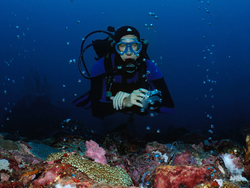
uerto Galera Biosphere Reserve is situated on Mindoro Island, about 120 km south of Manila.Its 23,200 hectares make up the northern tip of Mindoro Island and are bounded to the north by the Verde Island Passage, to the west by the Camarong River and to the east by the municipality of San Teodoro.Ecosystems represented here are savannas and grasslands, dipterocarp forests, mossy forests, mangrove, coral reefs and coastal ecosystems as well as agroforestry systems.A wide variety of endemic species are present, including tamaraw (Bubalus mindorensis). The conservation of coral reefs has been recognized as one of the main tasks of the biosphere reserve since healthy coral reefs are important for the conservation of biodiversity, the maintenance of the traditional lifestyle and culture, tourism revenues, education and research.
Socio-Economics Characteristics
There are about 22,000 inhabitants in Puerto Galera (1996).Their traditional source of income used to be fishing and subsistence agriculture. However, after the boom of tourism at the end of the 1970’s, the service sector became more and more important.Today, the rapid and unregulated development of the tourist sector, which also led to population and economic growth, is the biggest problem of Puerto Galera.