UNESCO/Toson-Khulstai Biosphere Reserve
Sumaco
General information
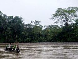
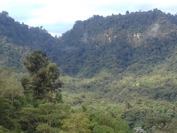
The Sumaco Biosphere Reserve is located 100 km south-east of Quito in western Napo province. There are numerous watercourses in the area, such as the Suno, Coca, Pitayacu and Pusuno Rivers. The Sumaco Volcano (3,900 meters above sea level) is a rather isolated peak lying to the east of the main Andean Mountain Range. It covers a large variety of ecosystems from the tropical highlands-Andean paramour to the tropical Amazon plains.

Detailed information
Key data
Year of nomination
2000
Country
Ecuador
Total population
206400
Area
Surface
931,930.00 ha
Total terresterial area
931,930.00 ha
Location
Latitiude: -0.571667 - Longitude: -77.4933
Contact
Ecological Characteristics
The Biosphere Reservecontains a mosaic of natural areasand areas of agricultural production. The types of soil cover range from non-intervention forests in the core zone to intensive land use, such as cultivation areas in the transition subzone. The types of cover referred to include: Natural forest, intervened natural forest, shrub vegetation, herbaceous vegetation, grasses and crops.The core and buffer zones of the Biosphere Reserve are the main sources for maintaining biological diversity. They contain representative examples of the country's tropical rainforest and the Amazon region; at the same time, they constitute a source of wealth for research, education and maintenance of habitats of singular importance. It is worth mentioning that in the transition zone there are still large areas covered with natural forests that enable their use through the maintenance of traditional practices and the sustainable use of these resources.
Socio-Economics Characteristics
The local economy is based on the production ofagricultural products such as coffee, cocoa, naranjilla and guayusa with agroforestry systems. In some cases, such as cocoa, efforts have been made to scale up the production chain and production has begun to articulate with important international markets (such as the United States and Europe).