UNESCO/Toson-Khulstai Biosphere Reserve
Ĺ˝łÜ±ąľ±˛ÔłŮ˛ą˛ő
General information
Zuvintas, Lithuania, is located in the southern part of the Middle Lithuanian Lowlands. It represents approximately 60,000 ha and includes lakes, wetlands, mires, peatbogs, and pine tree stands. Its great variety of habitats and vegetation renders this location very rich in biodiversity. When designated, the biosphere reserve will be inscribed in national law as a specific category. The main human activities include agriculture, forestry and fishing, with the recent development of eco-farming and tourism.

Detailed information
Key data
Year of nomination
2011
Country
Lithuania
Total population
831
Area
Surface
60,274.00 ha
Location
Latitiude: 54.469 - Longitude: 23.558
Contact
Ecological Characteristics
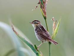
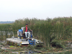
The site is located in the southern part of the Middle Lithuanian lowlands. It comprises Ĺ˝łÜ±ąľ±˛ÔłŮ˛ą˛ő and Amalvas wetland complexes, formed in a depression of the limnoglacial plain surrounded by moraine hill ranges, and Bukta forest on moraine plain.The site is very diverse with inland wetlands having some of the biggest habitats of this type in Lithuania. Ĺ˝łÜ±ąľ±˛ÔłŮ˛ą˛ő (still largely intact) and Amalva mires dominate in the area. Ĺ˝łÜ±ąľ±˛ÔłŮ˛ą˛ő mire (6,847 ha) is the largest in the country. It consists of raised bog (71%), transitional mire and fen.To the north of the Ĺ˝łÜ±ąľ±˛ÔłŮ˛ą˛ő mire lies the similar, but smaller Amalva mire (3,414 ha). There are three big lakes in the site: Ĺ˝łÜ±ąľ±˛ÔłŮ˛ą˛ő, Ĺ˝altytis, and Amalvas.The Ĺ˝łÜ±ąľ±˛ÔłŮ˛ą˛ő Lake (971 ha) is only a small remnant of the former post-glacial lake. It is surrounded by reed-swamps, sedge fens (mainly in its south-eastern part) and raised bogs. The lake has two main inlets: Bambena, Kiaulycia and an outlet – the Dovine River. Ĺ˝łÜ±ąľ±˛ÔłŮ˛ą˛ő and Amalvas lakes belong to the Dovine river catchment area (589 km²). More than half of it (345 km²) is the catchment area of the Ĺ˝łÜ±ąľ±˛ÔłŮ˛ą˛ő Lake. A great diversity of habitats and vegetation creates excellent conditions for numerous waterfowl and other species.Many different land cover and habitat types - from untouched raised bogs and pristine forests to agricultural lands and settlements - are found in the area. There are no people living in the core area of the biosphere reserve. There are only 1,100 inhabitants living within the buffer zone.The core area of the biosphere reserve consists of strict nature reserves (IUCN category I) and nature reserves (IUCN category IV). There are Ĺ˝łÜ±ąľ±˛ÔłŮ˛ą˛ő (the oldest protected area in Lithuania - since 1937), Buktbale and Liuliškyne strict nature reserves and Amalvas, Kiaulycia, Ĺ˝altytis, Ĺ˝elsva, PaĹľelsviai, and Liepakojai nature reserves. The buffer zone consists of ecosystem restoration zone, ecological protection zone, and forestry and agriculture zone. The biosphere reserve is contiguous.
Socio-Economics Characteristics
The Ĺ˝łÜ±ąľ±˛ÔłŮ˛ą˛ő lies in the intensive farming region. Traditional hay-mowing and pasturage practices, especially in fen grasslands, were widely applied in these areas for a long period. The site offers high nature values, very well suited for growing eco-tourism and rural development. The protected area’s staff also seeks to foster the economic and social well being of local communities within the site and in the neighbourhood. The oldest protected area in Lithuania is particularly important as example of the nature conservation, education and scientific research. The site has all necessary facilities for visitors and researchers: nature paths, visitor centre, nature museum, and lodging for researchers. This infrastructure is currently under enlargement and modernization. Various projects on conservation of biodiversity, agro-environment, rural development, water management issues are ongoing in the protected area.